Tuesday, May 31, 2011

Mt. Pulag, Benguet

my adBENtiyur
November 2008


me
Mitch
Sabit Mountaineers


It was really a trip to remember, Imagine carrying to bags, cold weather, low stamina, basically unfit to this climb, but still manages to conquer Pulag. 


Sad thing is, halfway to the summit I decided to turn around because our guide is telling us that there is a strong possibility that we might not see a beautiful sunrise above the clouds because of the weather.  Good thing is, it was so cold that I feel my face freezing due to the raindrops. that we decided to follow the advice of our guide and just return to the campsite.


I don't really get cold that easily, I can stay outside the tent when I'm taytay falls, while it was raining during night time, But this is pretty much what separates me from thinking I'm a snowman.    


About the place

Mount Pulag (or sometimes Mount Pulog) is the third highest mountain in the Philippines. It is Luzon’s highest peak at 2,922 meters above sea level. The borders between the provinces of Benguet, Ifugao, and Nueva Vizcaya meet at the mountain's peak.
Because of its high elevation, the climate on Mount Pulag is temperate with rains predominating the whole year. Rainfall on the mountain averages 4,489 mm yearly with August being the wettest month with an average rainfall of 1,135 mm. Snow has not fallen on its top in at least the past 100 years.
There is also a lot of trail to go here, but the most popular is ambangeg trail and the akiki trail, ambangeg is more easier than the akiki.

How to go here
From Baguio you can chartered a jeep going to ambangeg, then you'll proceed to the visitors area for some orientation of the place and the peoples culture. from there you'll then proceed to the ranger station where you can eat your lunch before proceeding to camp 1 and 2.

Tips
Bring clothes that can keep you warm, it really freezes over here. Gloves, Bonnets and a extra pair of socks is a must. 


View Larger Map
paMITCHyur

clouds flowing like water

at the registration area 

at the campsite of mt. pulag

the trail to the campsite

sunset


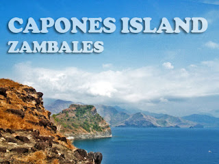
Capones Island, Zambales

my adBENtiyur
2008


me 
Mitch
Mar
Outdoor Addicts


This trip is just a side trip from the Outdoor Addicts Anawangin Tour. Sad to say that we did not get to spend it with our hiking buddies  theTribe trends.


About the Place

It is located at San Antonio, Zambales. Capones Island is one of the main attractions in Pundaquit Zambales. The island is actually a big lump of rock formation with very little soil. The beach in this place is composed or rocks and sands, The strong waves hitting the islands making it not a suitable swimming spot.
But not enjoying the beach will make you enjoy the island more by exploring it and taking a short hike to the lighthouse. The lighthouse is at the back of the island when you’re facing the open sea. Be sure to carry some water with you and if you can, just leave some of your stuffs to the boatman. The hike is short but steep. 
You can also do a sidetrip to Anawangin cove from capones island.

How to go here
Public Transportation
Ride a bus going to Sta Cruz or Iba Zambales
Go down at San Antonio, Zambales
Ride a tricycle going to Pundaquit
Arrange a boat ride to Capones Island.


Tips
Remember to bring a water proof bad or even a plastic just to protect your things from the splashing waters, Wear protective clothing from the sun, malong would be helpful during the boat ride and the trek to the lighthouse.


View Larger Map


paMITCHyur


capones island, viewed from pundaquit beach

the lighthouse

the trail going to the lighthouse


trail to the lighthouse


Friday, May 27, 2011

Mt. Manalmon, San Miguel, Bulacan

my adBENtiyur
2007


me
Mitch
Nick
Mar
Geru
Harry
Gay
Gelaine
Janice
Nonoy
sir Sam and Wife


Our trip to mt. Manalmon took us around 1 month to execute for many different reasons, but mostly because of our schedule. At kahit na di kami magkakasabay papunta duon, naisip namin na ituloy parin. Nauna ang group ni nic, harry and roger plus the trends pipol ( sir sam, misis ni sir sam, gelaine, janice at gay). they leave in the morning while my group with mitch, mar and nonoy leaves in the afternoon. Its not really hard to commute going there, cause many buses are available and plenty of different terminals are located around metro manila. We choose the one in TRAMO Pasay, (5 star Bus Line) and when we have reached Kamias in San Miguel Bulacn , we rode a tricycle to madlum. It took us 3 hours to reach baranggay Madlum including the bus and the tryke ride, just enough time for nics group to finished caving, spelunking and explore the place. Swerte naman that when we arrived Madlum that they have finished they're earlier activities and proceeded to start the hike to Mt. Manalmon together like one big happy family.
The hike was not really that hard mainly because we been looking forward to this and the mountain is not that high compared to the other mountains we have climb. Plus the fact that my group did not participate with their earlier adventure that ive heard is quite exhausting.
Even though their tired already we managed to camp at the campsite near the summit. While installing our tents some of us started to cook rice and other stuffs. We had a very delicious dinner and a very fun fuilled socials that night. We drink my version of The MINDORO sling and we sang songs while playing guitar.

The next day I was one of the first to got up to appreciate the sunrise. And it does'nt disappoint me for its offer me a great view of the sorroundings and the ray of light that is slowly bursting to the sky.( the main reason why i wanted to camp near the summit), I called them up and one by one they find themselves with me and we took pictures and more pictures.

After all of that , Its breakfast time and again everybody help in preparing our breakfast, a little rest after breakfast we started to disassemble our tents and proceed to the training area.  It took us only 30 mintes to do it plus our guide give us a little token, a gift from above and we named him manalmon (mon for Short).
About the Place
Mt. Manalmon is located at San, Miguel Bulacan at Baranggay Madlum. Travel time will be around three hours and the hike to the summit will cost you another 1 to 2 hours.


This place is also near the Biak na Bato park.  Bayukbok cave is also a point of interest when you go to this place so make sure you put it in your itinerary.


The hike will also pass thru rivers and cave system.  There is also alot of stores near the jump-off point where after the hike you can swim around in its refreshing waters.


How to go here
To go to San Miguel, Bulacan you can ride a bus going to Cabanatuan, The bus will pass by San Miguel Bulacan and be sure to go down at baranggay Camias. This will take you 1 1/2 to 2 hours

From there you can then ride a tricycle to go to Madlum, just tell the driver that your going to Manalmon.

Tips

The bus fare will cost you around 112 pesos if you take the 5 star busline in Tramo Pasay, The tryke will cost you 50 pesos per head. Plus a guide is required, so you'll have to pay around 300 to 500 depends on the itinerary and the numbers of person in your group. You can go to the training center to ask for a guide.

A campsite is located at the foot of Manalmon which is just beside the river for those who want to take it the easy way. But for those who want to see the beauty of the place and willing to sacrifice sweat, a campsite near the summit that can pretty much accommodates 8 to 15 tents is advisable.

Please keep in mind that during the rainy season this place tends to be very slippery. Bring insect repellent and extra water if you are camping at the summit. There is no water source at the summit and even though the water is clear make sure to treat the water first when you plan on drinking it


View Larger Map


paMITCHyur

Twin Falls, Cavinti Laguna

my adBEN tiyur
2005


me
Mitch


This trip has not enough planning nor preparation, it supposed to be a day trip but due to the fact that we got to Sta Cruz, Laguna already kinda late, we decided to stay there overnight.

At first excitement fills the air while trekking to the campsite. then a little dissapointment comes in because of the murky waters. But still we decided to swim, what the hell we are already there might as well enjoy the waters. 

As time goes by it occured to us that we are the only campers here, anxiety stuck into me but then again what bad could possibly happen right.  Well nothing bad really happened but I was scared as hell. Maybe it just me but there is something weird in this place something that gives me goosebumps. 

I did not manage to sleep the whole evening, At the first sign of light around 5 am, I quickly prepared are breakfast, we ate and packed our things up. then headed to the park to go home.    


About the place
The trip alone is enjoyable because it will show you scenic sights around Laguna particularly the man-made Kaliraya Lake which is a favorite tourist destination. The hike officially starts at the Japanese Botanical Garden, a project of the former First Lady Imelda Marcos, and a favorite picnic ground during weekends.

Take time and explore the beauty of the garden. A short hike will bring you to the river system ending in the twin-falls. The campsite can be either established at the flat area before the waterfalls or at the small shoreline of the river basin. Either way, you need to ask permission from the caretaker of the place.

The bigger falls has a platform where you can climb and enjoy the "hard massage" the waterfall will give you. Swimming is definitely enjoyable with a wide and deep basin you can play around. The dead tree trunk in the center of the river is a favorite mating place of exotic dragonflies, so don't miss it. The place was called "twin falls" because of the two waterfalls existing side by side at the wide river basin.

One of the light hiking destination for weekend hikers and beginners as well as non-hikers, the Twin Falls in Cavinti, Laguna is one beautiful destination to go to with a well-established trail that would entail only 1-hour of hike to reach the destination.

Because of its relatively easily accessible destination point as well as a beautiful park located at its jump-off point, the place is ideal for introducing hiking to beginners as well as a place to bring non-hikers to enjoy nature without the hassle of strenuous hikes and inconvenient facilities.

But for those who are scardy cat like me see to it that you go in numbers, plus when you go during rainy season, for you might find yourselves alone in the campsite and its really really scary.. From the waterfalls, you can have a family picnic or swimming on the wide and deep basin at the base of the falls. It is truly more of an excursion or "walk in the park" than nature hiking.

How to go here
To go there, you can start by taking a bus towards Sta. Cruz, Laguna. From there, go to the public market where you can catch a jeepney ride towards Cavinti. Remember to verify with the driver if it would pass by the Japanese Botanical Garden.

Tips
Cavinti Twin Falls is open anytime of the year. The problem is that it lies within private properties so its existence relies on the discretion of the owner of the property. There are rumors that the place will be developed as a housing project which is the main concern regarding the preservation of the waterfalls.

The water tend to get murky during rainy season. This place is not well known like majayjay or famy so expect a very low number or campers.


View Larger Map


paMITCHyur

Thursday, May 26, 2011

Mt. Manabu, Sto Tomas, Batangas

My AdBENtiyur
January 2008

Me
Mitch
Marie
Nic
Harry and Honey

Our trip to this place was blasted by rains from the start, from Buendia to Sto, Tomas from the jump-off point to the campsite, the rain stop for two hours in the afternoon just enough time for us to prepare dinner. Good thing that it occurred to us to eat early.

It began raining again but this time it was really hard, and it was raining from different directions, from 6 pm to 2 am, It was cold our clothes were wet and to make the things worst it was as cold as ice. Plus there was no clearing to make nightscape photos.

In the morning the weather was better but still due to the clouds, there is still no clearing for a good photo shoot.  

I also left tungkod here my companion in every hike.

About the place
Manabu is located at Batangas, It is one of the minor climbs here in the Calabarzon area.  You can see Mt. Maculot from here if the skies are clear. The campsite is not suitable for many campers, especially when it rains.

There are also some stores just a few meters away from the jump off point and they would pretty much offer you free coffee.   
How to go here
Mt. Manabu is located in Sulok, Brgy Sta Cruz, Sto Tomas Batangas, the easiest way is catch a bus going to Lucena or San Pablo. Get down in Brgy San Pedro in Sto Tomas Batangas. From there catch a tryke going to Sulok, brgy Sta Cruz, Sto Tomas Batangas.

Tips
Manabu is near the Lipa so if you are not commuting going there it is advisable to ply the Lipa route. At the jump off point there is a secured parking area that will only charge you 100 pesos for overnight accomodation of your vehicle. This is also where you can take a refreshing bath for 10 pesos after the trek. The trek is not that hard just make sure to go there during summer, for the trail tends to go slippery when it rains.

Plus there is no water source at the campsite but 30 - 40 mins away from the campsite there is a hut that can offer you water and coffee. There is also buko for sale at 10 pesos. It is safe and the people are very friendly and its a very nice place.


View Larger Map

paMITCHyur

Mt. Famy (Romelo), Siniloan, Laguna

My AdBENtiyur
2005

Me
Mitch
Mar
Marie
Edward
Butch

I’ve been to this place twice, the first was a blast, we where blasted by rain throughout the night, It was so hard for me because I was carrying a super-kalan inside my bag. Thankfully we managed to find a horse man, halfway to our journey. Well for a small amount of money versus the hardship of carrying the super-kalan, I would gladly pay that man again.

The second trip, I was more prepared. But still asked for the assistance of a horseman, I was thinking why pro-long the agony if I’m just going to give up in the end anyway.  Damn that super kalan.


About the place
Mt. Famy also known as Mt. Romelo is located at Siniloan Laguna, It is famous for its waterfalls mainly the Buruwisan falls, it is said that Mt. Famy have 5 waterfalls but I have only been to two of those five. It is also suitable for swimming due to its vast water basins.

It also has a potable water source not far from the campsite not to mention sari-sari stores everywhere. If you want you can also rent a horse, not for riding mainly for carrying your stuffs.

In the summer the water flowing beside the campsite decreases and In the rainy season it tends to get very slippery and the term that you will kiss the earth is true (based on experience) but you can put it to fun by counting the person who has the most slip ups.


How to go here
2 routes are available going to Mt. Famy, you can either go to the Tanay route where you will pass the scenic town of Rizal and Laguna de bay, or you can ride a bus going to Sta Cruz Laguna and from there you can take a jeepney going to Siniloan, where it will pass towns like Paete and Pagsanjan. It will both end up at the terminal of Siniloan and from there you will take a tricycle going to Mt. Famy. It will be a few meters walk from the highway to the jump-off point where you have to register.

Tips
You can either hire a horse to carry your stuffs or carry it yourself. It is advisable to go during the summer for its gets very slippery during the rain.(come to think of it we always go there during the rainy season). Well Rain means water, and it means more water to play around. There are a lot of Sari-Sari Stores at the campsite. There is also a potable drinking water just a few meters away from the campsite.


View Larger Map

paMITCHyur

Monday, May 23, 2011

Sunday, May 22, 2011

Mt. Batulao, Nasugbu Batangas

my adBENityur
February 2008


Me
Mitch
Jay
and Group


Its the most tiring trip that I ever done. Maybe because the trek would cost you 2 to 3 hours and maybe longer to some or because this is the first time that I've done a day trek that cost me more hours going there than staying there.

The day started with a 4 am call time at edsa rotonda chowking at Pasay. The bus bound to Balayan Batangas took off at exactly 430 am. It took us 1 and a half hour to arrived at Evercrest. A tryke ride away from the jump off point. Since it was early and none of us haven't had their breakfast the group decided to eat at Ate Fes karinderia. After filling our stomachs with papaitan we catch a tryke then proceed to the jump-off point. The first two hours of the trek is easy plus the cool climate really helps when passing by open fields. Not to mention packing light really helps conserve energy.

After resting / photo session at the summit for 30 minutes, we decided to go down at camp 1 where we plan to take our lunch and 1 hour of rest. Going down is harder than going up from camp 10 - 7 but easier as we manage to reach camp 6 t0 1.

Well to cut it all short, the trip was fun, the halo halo located at the trail lacked sugar and taste, but refreshing nonetheless. The locals our very kind that some even bother cooking up corn for us. and our guide is a really cool kid, Plus eating dinner at chowking completes it all. Thanks to Jay / Trix / The lovers from Lucena / Gary / the tall guy / and specially my gf Mitch for making this trip possible.


About the place
The trip would eventually lead you to the camps namely 1-10, ten is located at the summit. Camp 1 to 6 are relatively easy due to the fact that the distance between each camps are closer plus the terrain is not that steep. But 7 -10 is where you separate the man from the boys. The terrain of camp 7-8 is steep and the loose rocks, makes it harder to get a grip. 8-9 is where you will experience wall climbing, with 70 degrees and 20 foot high of rock and earth as your wall.
9-10 is the easiest of the 3 but still one wrong move will be the last move you'll ever make.


How to Get here
Catch a bus bound to Balayan Batangas (CROW) Edsa Rotonda near Chowking Pasay. Get down at Evercrest Golf Course. Catch a tryke ride to the jump-off point.

From the jump off point it will be a 1-2 hours hike to camp 1. From camp 1 to the summit another 1 hour.

Tips 
Batulao is located in Batangas town of Nasugbu. Refreshments are available at camp 1 and camp 6. Halohalo and other refreshments are also available in some part of the trail.

Wear protective clothing, the hike in the open field would probably cause you sunburn, sunblock is a plus factor in this trek. Wear hiking shoes, the hike from camp 7 to 10 is the hardest part of this trek, in sunny day the trail from camp 7 - 8 is very slippery because of the unsettled soil and dirt.


View Larger Map
paMITCHyur

Calayo Cove, Nasugbu, Batangas

my adBENtiyur
April 2008


Me
Mitch
Mar
Marie
Nick
Roger
Sir Sam and Family
plus friends


Our trip here is one of the best, first it was one of the few times that the actual original member of the TRIBE were present, second the food is almost free flowing, third, it is one of the trips that Princess (our dog) is with us, lastly because we didn't have to hike or walk for a long time and the travel time is not that much burden.


About the place
It is located at a small town of Nasugbu Batangas, Just near the vicinity of Pico de Loro Cove.
Plus I think that there is this road which is still under construction, that will make it possible to go here via ternate.


HOW TO GET HERE

If your planning to go here, I suggest that you bring a car, From Manila go to Tagaytay via Cavite-Coastal Road or South Super h-way and exit at Sta Rosa Laguna. The place is located near Pico de Loro Cove and Punta Fuego so it has the same route.

Tips
There are available water source near the beach, (deep well),it also has a common bathroom and  it is located at a small barrio (community) that has plenty of sari sari stores where you can buy stuffs. I don't think that there offering accommodation though. 


View Larger Map


maMITCHyur


Friday, May 20, 2011

Gulugod Baboy, Mabini, Batangas

My adBENtiyur
November 2006


Me
Mitch
Roger
Nick
Marimar
Cj and Mike

Our trip to Gulugod Baboy is quite exciting, first, no one in our group had been there, which means we are clueless about the terrain, climate, the wind condition and the locals living there. The solution bring the basic stuff and enough supplement for the trip.
Second, We didn't get lost or anything like that, thanks to the sign at the nearby store (to gologod baboy) and the clear trail.
Third, the hike wasn't really that hard come to think of it. I think Maculot is much harder, (but maculot has halo halo store at the campsite plus it has ice cold buko juice in some resting area) well Glgd baboy will make you appreciate nature at its finest. No stores means less trash and less expenses.
Fourth, it is quite accessible, ride a bus bound for Batangas city a jeep to Anilao/Mabini and a jeep to philpan dive resort , walla! 
and finally the locals are very friendly.... plus the lomi is very tasty and satisfying too bad we did not managed to take a dip at the blue sea water of anilao...


About the place
Gulugod Baboy is located at Anilao/Mabini Batangas. It is one of the minor climbs around Calabarzon .
The trek is very easy for those who experienced Maculot or Famy this will be a piece of cake for you guys. The only difficult part is when it rains.
It also has a great camping ground that can accommodates 5 -10 tents. Near the campsite is a shanty where you can charge your phones or even ask for water.


How to go here
First you need to ride a Batagas City Pier Bound Bus.. the fare is around 146 pesos, tell the conductor you are going to Anilao. Form Batangas City you will catch a jeep bound to Mabini/Anilao the fare is around 23.50 pesos (just tell the driver that you are going to Anilao). Again you'll find yourself in a terminal of jeepneys.. just tell them you are going to Philpan resort the fare is around 14.00 pesos. from philpan resort you will see a cemented path going up. You can either start the hike or eat first at nearby stores (I recommend the lomihan just beside philpan resort)
(all the prices are based on the year 2006)


Tips
You must consider packing lightly for there will be steep portion throughout the hike, water source is available near the summit just look for a shanty near the campsite, and wear protective clothing from the sun.

View Larger Map


paMITCHyur

Malibiclibic Falls, Aguinaldo, Cavite

My AdBENtiyur
April 2006

Me
Mitch
Roger

Our trip to Malibiclibic falls is quite an experience. First there are only three of us who are available for this trip, 2nd we have limited information about the place that I gathered from the net, and third we still can’t decide if it’s going to be a day hike or we will stay through the night. It’s a good thing that waypoints post something about the place and also thanks to Angel Juarez who
e-mailed me some pointers and tips on how to go there and the safety of the place.

Malibiclibic falls is located at Brgy. Lumipa, Aguinaldo Cavite. It is quite intriguing because Cavite is not known for waterfalls, so we decide to investigate; it took us 2 to 3 hours to arrive at Malibiclibic Falls, 2 hours from Baclaran to Alfonso Cavite and another hour going to Alfonso to Aguinaldo to Brgy Lumipa to the falls.

Plus the basin is quite deep at least 15 to 18 feet deep. It’s a good thing that there are some bamboos available and already cut during are trip there, we managed to make a BALSA / RAFT with the help of Roger and my GF Mitch, they tie the poles together while I supervised them.

Well to cut things short, it’s a nice place to go and spend your weekend not expensive and very near to Manila. By the way it has a nice place to camp.

About the place
Malibiclibic Falls is located at Brgy Lumipa at Aguinaldo, Cavite. It is one of the lesser known waterfalls in the country and one of the 2 waterfalls of cavite.

The trek is very easy for those who experienced Maculot or Famy this will be a piece of cake for you guys. The only difficult part is climbing rocks which tend to get very slippery during rainy season.

It also has a great camping ground that can accomodate 3-5 tents. The catch basin is very ideal for swimming for those who knows how to swim, for the water is not that shallow. It also has wildlife like monkeys, snakes, birds, bats and some says that crocodiles lives here.

How to go here
From Baclaran catch a bus ride going to Alfonso Cavite, then ride a jeep going to Brgy Lumipa, Aguinaldo. From there ask assistance from the brgy.

Tips
The trail is not that steep but it tends to get slippery during rainy season.
If you can bring some floating device to enjoy the catch basin of the waterfalls, the water is deep around most areas.


View Larger Map

paMITCHyur

Thursday, May 19, 2011

Pagudpod Beach, Ilocos Norte

My AdBENtiyur
July 2008


Me
Mitch
Mar
Marie
Lara and Mark
Len and Husband

My adventure at Pagudpod is part of the Northern Exposure trip made possible by the RACE group. Pagudpod is very popular here at the Philippines for its beautiful beaches, the only hassle is the travel time and the budget.

When Marimar got an invitation from Race she immediately asked us if we are interested to join. I asked some of my officemates and they quickly decided to go and they’ll take their partners.

Unfortunately we did not have a chance to take a dip to its refreshing waters but I manage to dip my foot in its waters. My group decided to take a tour to the windmills instead of swimming. I think it was the best choice that time, having a very limited time, I won’t spend it swimming during a very hot sunny day, plus it was my first time to see a wind turbine up close.

After taking hundreds of pictures at the windmills, we left to eat lunch at Pagudpod beach. Well for now I’ll make do with taking pictures here but time will come that I won’t be bound by any schedule, that I can just lay my body to the waters for as long as I wanted.

About the place
Its one of the best beaches here in Luzon. The travel time is 10 hrs by land. There is a lot of place to go and activities when you are at Pagudpod. You can do trekking to Kabigan Waterfalls, do some surfing. Take a trip to Bangui windmills or better yet the Bojeador lighthouse.

How to go here
By land
You can take the Florida bus line from Sampaloc Manila (Manila to Pagudpod trip)
or other buses like Partas, Baliwag or Farinas (Manila to Laoag trip)
from Laoag it’s a 2 hours Jeep ride to Pagudpod

Tips
There’s a lot of resorts there for accommodation feel free to do some research first about the packages before committing to one.

View Larger Map

paMITCHyur


Anawangin Cove, Zambales

My AdBENtiyur
January 2008

Me my GF Mitch (now my wife)
Mark
Arvee
Lee
Cherry and a friend
Ren with Gf (now his ex) with her brother
Manong Driver

It all started when my workmates asked me to help them looked for a place to go, somewhere we can relax, somewhere beautiful, somewhere new and of course somewhere cheap. The original plan was make it an exclusive trip for MIS personnel only, but since I’m the one who is going to look for a place, I was given a special pass.

It took a few hours of my working time searching for a place, the moment I saw a photo of this place, I was in disbelief of its beauty and assets. The composition of this place is just not natural for me. Imagine a beach, but instead of the usual coconut tree, you’ll see hundreds of pine tree, now imagine it still being clean and seemingly untouched despite being a few miles away from Manila.

We did not waste time upon seeing a photo of this place, we only need is to arranged a budget for transportation, food and beers. The accommodation is simple. We just need to produce 4 to 5 tents.

So we now have a place to go, the only problem is to make this trip to reality. To make it happen we must first secure a commitment from the group. But after a week, most of them just backed-out and we need them because the budget will be too expensive to be shouldered by 4 persons. We need to work around it so we decided to open this trip to some friends. First I invited Mitch my GF, Ren Invited his GF and his GF‘s brother, Mark paid for Arvee and we then asked Cherry to come and that she can bring a friend.

After all the preparations and the very tight budgeting, we are finally on our way to Anawangin, riding a 15 seater Nissan Urvan the only separating us from the beauty is the road ahead. It took us more than 2 hours to arrive at Pundaquit, San Antonio Zambales, plus another 30 minutes for the boat ride to Anawangin Cove.

I was amazed by its beauty and serenity. It was a hidden beach paradise, a stunning place just a few hours away from Manila. I told myself this is one of my favorite places and I’ll return here next year.

I did return here the year after, but to my disappointment it was crowded and noisy, I guess that’s what happens when different kind of people goes to a place. I’m just praying that they’ll maintain its beauty and unpolluted surroundings.


About the place
It is located at San Antonio, Zambales. It is enclosed by mountain, makes it only passable by sea travel or a long hour hike. A local from the area told me that there is a proposal to create an access road to this place. He also told me that there are accidents happening here mostly drowning. But most of the time the victims are drunk and thoese who can’t swim.  

It also has a stream of water just a few meters away from the camping area. It is also near to Nagsasa Cove.

How to go here
Public Transportation
Ride a bus going to Sta Cruz or Iba Zambales
Go down at San Antonio, Zambales
Ride a tricycle going to Pundaquit
Arrange a boat ride to Anawangin


Tips
There is no Cellphone signal and no stores here. So make sure to bring flashlight, water food and batteries. Also there is no accommodation here but the last time I checked there is a cr. Plus somewhere in the middle of the cove there is a sandbar don’t go there alone. Most of the time accidents happen there due to water currents pushing you off the sandbar.    

View Larger Map

paMITCHyur